SITE PROGRESS MONITORING
CONSTRUCTION – CIVIL – MINING
Keeping track of site progression is crucial for staying on schedule and within budget. AIR360 provides an efficient way to monitor every stage of a project, offering high-resolution data and near real-time insights that traditional methods simply can’t match.
Compared to satellite imagery or manned aircraft, drones can fly much lower, capturing sharper, more detailed data—without the hefty price tag. It’s a smarter, more cost-effective way to survey your site with precision.
By integrating drones into site progression monitoring, construction teams and project managers gain a smarter, safer, and more efficient way to track, measure, and analyse projects in near real time.
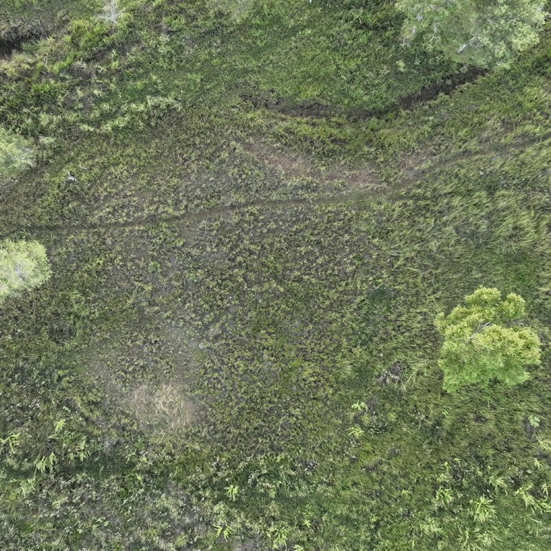
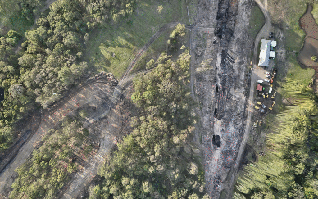
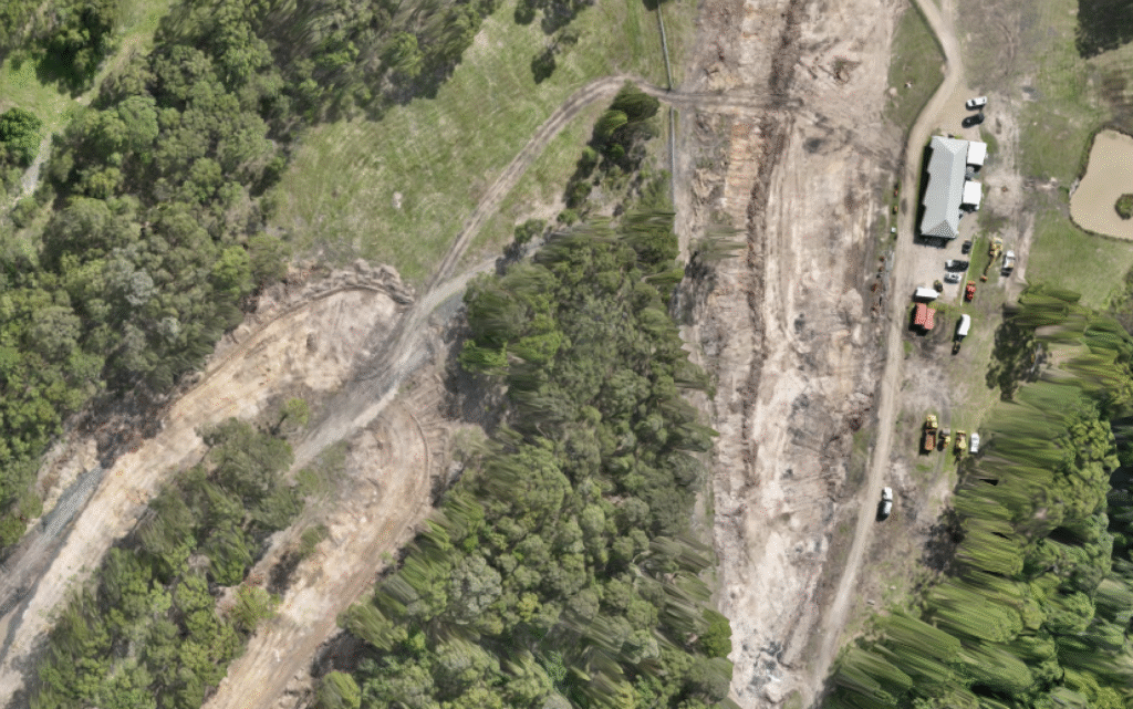
REHABILITATION REPORTING
Monitor land rehabilitation, track vegetation regrowth, assess erosion, and ensure compliance with environmental restoration plans.

Virtual Desktop Inspections
Eliminate the need for physical site visits. Teams can analyze site conditions from their desktops, saving time and reducing the need for unnecessary travel.
Measure & Annotate
Take precise measurements, mark up images, and annotate directly within the 2D or 3D models. This streamlines communication, making it easier to relay information to contractors, engineers, and stakeholders
Timeline Analysis
Allow project managers to visually track progress over days, weeks, or months, by comparing past and present data. Teams can identify delays, plan resources, and keep stakeholders informed with clear, visual updates

Volumetric Calculations
Calculate stockpile volumes, cut-and-fill requirements, and earthwork movement. Optimize material usage, reduce waste, and improve cost forecasting without the need for manual surveys
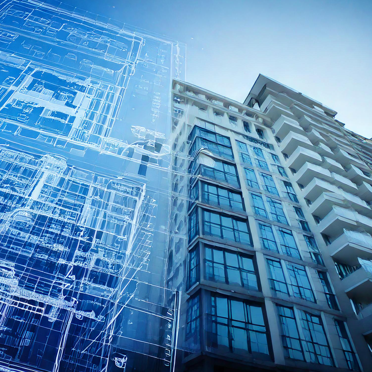
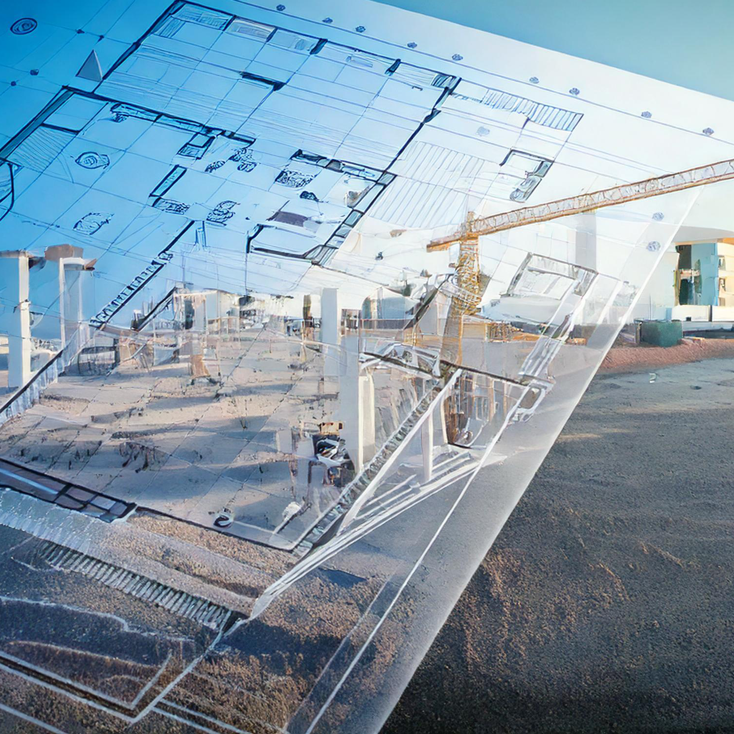
Plans & Map Overlays
Blueprints and site maps can be overlaid onto real-world imagery, ensuring construction aligns with the original plans. This helps detect deviations early, reducing costly rework
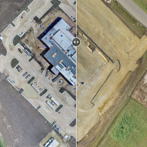
Comparison Over Time
Create a visual timeline of site development. This historical data is invaluable for identifying trends, improving future project planning, and ensuring compliance with contractual milestones.
MONITOR YOUR SITE LIKE NEVER BEFORE
By integrating drones into Progression Monitoring & Reporting, project and site managers gain a smarter, safer and more efficient way to track, measure, and analyse projects.
Accurately Calculate Volumes from your Desktop
Accurate material management is critical for budgeting and planning. Giving you access to advanced photogrammetry software, you can perform volumetric calculations, measuring stockpile sizes, excavation levels, and earthwork progress on your sites with centimeter accuracy.
This data can help your teams monitor cut-and-fill operations, ensuring the right amount of material is moved or stored. It also allows for better cost forecasting, or quoting reducing waste and preventing over-ordering of materials. By eliminating the need for manual measurements—which are often time-consuming and prone to errors—drones can provide a faster, more reliable solution for managing materials on-site.
Visually Track Progress Over Time
Consistently tracking site progression is essential for keeping projects on schedule. Traditional methods rely on ground-based inspections and manual reporting, which can be slow and inconsistent. AIR360 can streamline this process by capturing high-resolution aerial imagery and generating 2D and 3D models at regular intervals.
With regular scheduled flight missions of the same area, project managers can create a visual timeline of the site’s development, tracking work completed and identifying any delays. This allows for proactive decision-making, better coordination of resources, and improved communication with stakeholders. Instead of relying on spreadsheets and reports, teams get a clear, real-world view of their project’s status.
Inspect, without leaving your desk!
Regular site scans can give the ability to analyze site data remotely. Instead of relying on physical site visits, engineers, surveyors, and project managers can all access cloud secure, common high-resolution images, videos, and 3D models from their desktops.
This not only saves time and travel costs but also improves collaboration. Multiple stakeholders can review the same data, make informed decisions, and provide feedback without needing to be on-site. It’s an efficient way to increase oversight while reducing disruption to daily operations.
Measure on your desktop. Not on your site.
Drone-captured data isn’t just for viewing. It’s interactive! Advanced software allows your teams to take precise measurements directly within digital models & maps, including distances, elevations, volumes and ground contours.
Additionally, engineers and managers can add annotations, comments, and markers to highlight critical areas, communicate potential issues, or provide instructions. This creates a more streamlined workflow, ensuring everyone, from contractors to executives, has access to accurate, secure, up-to-date information.
Overlay Design Plans to Real World Images
Ensuring a project aligns with its original design is crucial for avoiding costly rework.
Architectural blueprints, site plan, and geospatial maps can be accurately overlaid onto real-world imagery, allowing site managers to compare actual progress against planned layouts.
This capability is especially useful for detecting misalignments early, preventing mistakes that could require significant corrections down the line. By identifying discrepancies before they become major issues, teams can reduce rework costs, improve accuracy, and stay on schedule.
Accessibility. Safety. Efficiency.
Access difficult to reach terrain, while preventing ground crew safety hazards all while completing the task significantly faster than traditional methods.
Drones can play a crucial role in rehabilitation reporting by capturing imagery and data to monitor land recovery over time. They provide accurate assessments of vegetation regrowth, erosion, and environmental stability, ensuring compliance with restoration plans. Drones can identify rehabilitation issues that may be missed from the ground. This data helps environmental teams make informed decisions, adjust rehabilitation strategies, and demonstrate compliance with regulatory requirements. By reducing the need for manual site visits, drones also save time, lower costs, and improve safety in remote or hazardous areas.
We tailor our drone services to suit your needs, delivering 3D point cloud models, high-resolution orthomosaic maps, and crucially – Actionable Insights.
Let’s design a solution that works for you!
QUESTIONS
CONTACT US
We may be out flying right now, but please fill in your details below & we’ll get back to you as soon as possible!